
Depth conversion is a critical process in geophysics and the oil and gas industry. It involves translating time-based seismic data into depth measurements, allowing for a more accurate representation of subsurface geological formations. This article delves into the techniques and importance of depth conversion formula, shedding light on its fundamental principles and applications.
The Basics of Seismic Data
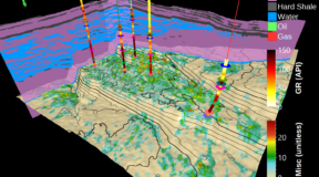
Seismic surveys generate data that helps in understanding subsurface geology. These surveys use sound waves, which travel through the Earth and reflect off various geological layers. The time it takes for these waves to return to the surface is recorded and used to create a time-based seismic image. While this data is invaluable, it only provides information in terms of travel time, not depth.
The Need for Depth Conversion
Depth conversion is necessary because time-based seismic data can be misleading due to variations in the speed of sound through different geological materials. Factors such as rock type, fluid content, and pressure can affect sound velocity, causing inaccuracies in depth estimation if not accounted for. Depth conversion translates travel time into actual depth, providing a clearer and more precise geological map.
Key Techniques in Depth Conversion
Several techniques are employed in depth conversion, each with its advantages and limitations. The choice of method depends on the complexity of the geology and the quality of available data.
- Velocity Models
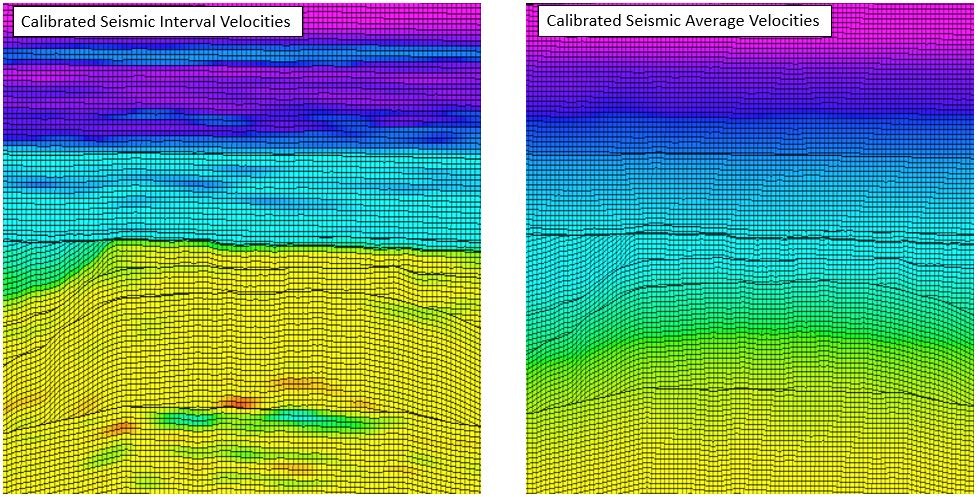
Velocity models are essential for depth conversion. These models describe how seismic velocities change with depth and across different geological formations. Common types of velocity models include:
- Interval Velocity Models: These models calculate the average velocity between two depth points. They are useful for simple geological settings but may lack accuracy in complex areas.
- Layer Cake Models: These assume a series of horizontal layers with constant velocities. They work well in regions with well-defined stratigraphy but can be inaccurate in areas with significant structural deformation.
- 3D Velocity Models: These are more sophisticated models that account for lateral velocity variations. They are built using seismic inversion techniques and well data, providing a more detailed and accurate velocity profile.
- Seismic Inversion
Seismic inversion converts seismic reflection data into quantitative rock property information. It provides a detailed velocity model by integrating seismic data with well logs and geological information. Inversion techniques can range from simple linear inversions to complex non-linear approaches.
- Time-Depth Relationships
Time-depth relationships (TDRs) are empirical correlations between seismic travel time and depth. These relationships are derived from well data where both time and depth measurements are available. TDRs are particularly useful for local depth conversion but may not be accurate for regions without well control.
- Geostatistical Methods
Geostatistical methods involve statistical techniques to interpolate and extrapolate velocity data across a geological area. These methods consider spatial correlations and provide probabilistic estimates of velocity, enhancing the robustness of depth conversion in areas with sparse data.
Applications of Depth Conversion
Depth conversion has wide-ranging applications in geosciences and the energy sector.
- Hydrocarbon Exploration and Production
In the oil and gas industry, accurate depth conversion is crucial for identifying and characterizing hydrocarbon reservoirs. It aids in determining the depth of target formations, estimating reservoir thickness, and planning drilling operations. Precise depth conversion minimizes the risk of drilling dry wells and optimizes resource extraction.
- Geological Mapping
Depth conversion enhances the accuracy of geological maps, providing better insights into subsurface structures such as faults, folds, and stratigraphic boundaries. These maps are essential for various geological studies, including tectonics, sedimentology, and mineral exploration.
- Geotechnical Engineering
In geotechnical engineering, depth conversion helps in the design and construction of subsurface structures like tunnels, foundations, and underground storage facilities. Accurate depth measurements ensure the stability and safety of these structures by providing reliable information about subsurface conditions.
- Environmental Studies
Depth conversion is also valuable in environmental studies, particularly in groundwater modelling and contamination assessment. It enables the accurate mapping of aquifers and the identification of potential contamination pathways, supporting effective environmental management and remediation efforts.
Challenges and Future Directions
Despite its importance, depth conversion poses several challenges. The accuracy of depth conversion depends on the quality and quantity of input data, such as seismic velocities and well logs. In areas with complex geology or limited data, achieving reliable depth conversion can be difficult.
Advancements in technology and methodologies continue to improve depth conversion techniques. Innovations such as machine learning and artificial intelligence are being integrated into geophysical workflows, enhancing the accuracy and efficiency of depth conversion processes. Additionally, the increasing availability of high-resolution seismic data and advanced computational tools promises further advancements in this field.
Conclusion
Depth conversion is a vital process that bridges the gap between time-based seismic data and accurate subsurface depth measurements. By employing various techniques and models, geoscientists can create precise geological maps that are essential for hydrocarbon exploration, geological mapping, geotechnical engineering, and environmental studies. As technology and methodologies evolve, the accuracy and applicability of depth conversion will continue to improve, driving advancements in geosciences and resource management.